It's finally happening.
The pesky El Nino, with warmer than normal surface waters across the central and eastern tropic Pacific, is finally dissipating.
And the effects of El Nino, including a wet California and warm Northwest, should be fading.
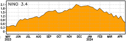
Consider the temperatures in the Nino 3.4 area of the tropical Pacific shown below (the difference from normal is illustrated). El Nino peaked in late November at around 2.1C above normal sea surface temperatures. Right now it is about 0.6C above normal and declining rapidly.


The latest prediction of the NOAA/NWS climate forecast model (CFSV2) is for the El Nino to be gone (0°C anomaly from normal) by the end of May (see below). And then we move into a strong La Nina (cold tropical Pacific) by autumn.

This model predicts the extension of colder-than-normal surface water over the tropical Pacific during the next few months (see below). Wow. Talk about oceanographic whiplash.

With El Nino weakening, the large-scale weather patterns are unlocking and the Northwest weather situation is forecast to be very different during the next weeks compared to earlier in the winter.
During El Nino winters (and this one), southern California is very wet, with the Northwest being on the drier side. In contrast, the latest forecast of accumulated prediction from the US GFS model through 11 May is shown below. Virtually nothing will fall over southern California and wet conditions will prevail over the Northwest.
Something has changed.

My suggestion: if you can make some good deals on ski equipment, do so....
____________________________
Announcement: I will do a special online zoom session at 10 AM on Saturday for Patreon supporters, with a deep dive into the upcoming wet period and the implications for this summer. Plus, I will answer your questions.
.gif)
.gif)

.gif)